Network of measuring stations documents differences in weather and climate in Freiburg's urban area
Freiburg, Jun 15, 2023
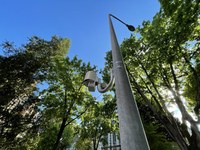
Measurement network focusing on heat in the city: Currently 42 stations in the Freiburg city area and the surrounding area record air temperature, humidity and precipitation. Photo: Chair of Environmental Meteorology
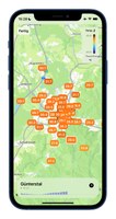
A thunderstorm is raging in the Zähringen district of Freiburg, but in Rieselfeld there is hardly a drop of rain. In Littenweiler, a pleasant breeze cools the hot summer evening, and in the northern industrial area there is no sign of the wind. "Within a city like Freiburg, there are major differences in weather and climate - but until now, these have hardly been recorded and have also been given little consideration in models of extreme events such as heat stress or flooding," says Prof. Dr. Andreas Christen, Professor of Environmental Meteorology at the University of Freiburg. A network of a good 40 measuring stations in the Freiburg city area and the surrounding region is now intended to change that. The data measured at the individual stations can be accessed by the public via the "uniWeather" app. It was developed by student Gregor Feigel as part of his project work. It is available free of charge in the App Store (for iOS only).
App allows for measuring station selection
All 42 stations currently measure air temperature, humidity and precipitation. They transmit the data every five minutes via mobile network. At 13 of the stations, air pressure, wind, solar radiation and radiation temperature are also recorded. With the help of these additional measured variables, the so-called heat stress can also be calculated at the respective stations, i.e. the heat or cold stress to which people are exposed there. “Our measurement network has a special focus on heat in the city, which is unique in this form,” says Christen.
In the app, measuring stations in different parts of the city can be selected individually as well as measured variables such as precipitation or PET (physiologically equivalent temperature), i.e. heat stress, can be displayed - including a graph for the past 24 hours. Maps show differences in the respective values in an overview of the city area. The current temperature of a selected measuring station can also be read on the lock screen of the cell phone.
City provides pylons and electricity
In setting up the measurement network, Christen and his team worked closely with the city of Freiburg, which, among other things, provides lampposts for mounting and the electricity to operate the stations. In the future, the city administration will also be able to use the University's data itself to register extreme weather events even more precisely. And climatic differences within the city could be included in longer-term urban planning. It is also planned that the city will make the data available to all interested parties free of charge in real time and historicized via its data portals.
Data for research
The measuring network was created at the University of Freiburg as part of the EU "urbisphere" project launched in 2020. "Freiburg will thus become a testing ground for urban climate models at several European universities and for weather services," says Christen, who heads the project. The researchers are using the data from the measurement network to develop new models that resolve climate changes and weather forecasts on a small scale: "We break down the developments to the level of city districts - for example, how do heat islands on hot days affect Weingarten and how Littenweiler?" The "urbisphere" project is based at several European universities and examines model cities worldwide. It will run until 2027 and is funded by a Synergy Grant from the European Research Council (ERC) of the EU with a total of twelve million euros.
Artificial intelligence calculates models
The joint project “I4C - Intelligence for Cities” run by the University of Freiburg and several Fraunhofer Institutes in Freiburg also uses the data from the measurement network. It uses artificial intelligence (AI) to research which parts of the city are particularly exposed to heat, floods and storms and how we can react to them. Considerations of ethics and privacy in the use of AI are also a topic. The project is led by computer scientist Prof. Dr. Thomas Brox, Professor for Pattern Recognition and Image Processing at the University of Freiburg, and is funded by the German Federal Ministry for the Environment as an “AI Lighthouse.”
The Freiburg app "uniWeather" for iOS is available for free in the App Store at https://apps.apple.com/de/app/uniweather/id6443663033.
Pressphoto for download
Contact:
Office of University and Science Communications
University of Freiburg
Tel.: 0761/203-4302
e-mail: kommunikation@zv.uni-freiburg.de


