A mobile tour through the Eternal City
Freiburg, Jul 16, 2018
Imparting knowledge digitally and thus understanding it better - that was the idea of the two historians Julian Zimmermann from the Department of History at the University of Freiburg and Julian Happes from the Institute for Politics and History at the University of Education (PH) Freiburg. During the summer semester, they gave a course in which students developed guided tours with an app through the city of Rome.
 Scientifically valid, but accessible to students: the tours take visitors to historically important stops in the city of Rome.
Photo: kasto/Fotolia
Happes and Zimmermann wanted to test new concepts of university teaching and to bring together the competences of the PH and the University through the seminar. “The digital world has not yet come to teacher training,” says Zimmermann: “So we had the idea to use an app as a didactic tool.” The Freiburg association Future History provided the technical prerequisite with a city guide app. “It was important to us to create something sustainable with added value - and the use of digital media is an important skill, especially for teachers-in-training,” adds Happes. The finished app will be used in schools to support the on-site experience on field trips. “We wanted to develop tours that are scientifically valid but at the same time accessible to students,” he explains.
Through the cooperation the two lecturers pursued a scientific as well as a didactic goal. “The PH students, for example, formulated the texts for the pictures in a didactically professional way, so that even school classes can use the information,” says Zimmermann. The students appreciated the heterogeneous group in which everyone could contribute their expertise and ideas. “Really good things came about through our discussions,” says Nadja Bergis, who is training to become a history teacher at the PH.
Houses, streets and hills
The seminar focused on transformation processes - from antiquity to the Middle Ages to 20th century fascism - using the example of the city of Rome. The students worked together in small groups on the issue of urban development and designed a route that passes important stops. They filled the app gradually with content. “I acquired the knowledge myself to develop a product. I can internalize the contents much better with such a goal in mind,” says Bergis.
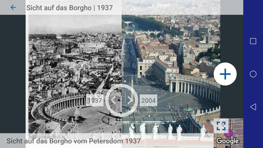
 1937 and 2004: The app illustrates how the municipality of Borgo, which stretches from Castel Sant'Angelo to the Vatican, has changed.
Photo: Julian Zimmermann
The stops are houses, streets or places in which buildings used to be located. Some images can be moved back and forth and allow a direct comparison between the current appearance of a place and, for example, an ancient reconstruction drawing. Another feature of the app uses augmented reality technology to overlay the photograph of an older building on the real image the camera is displaying. In addition, students used topographical plans and other useful materials that added value. For example, in the tour drawn up by Bergis’ group, which runs from south to north over Capitoline Hill, a map is included at the beginning: “In terms of Capitoline, it is essential how the hill is perceived throughout Rome. You cannot grasp its meaning in the big city when you’re at the top – a map is more useful than a photo.”
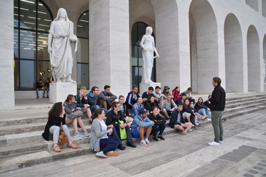
During the Pentecost break they went to Rome. For a week, the small groups ran through the various city guide routes. “If you walk 500 meters through the main shopping area in the afternoon, it can take a while. It was therefore important to test this directly on site,” says Happes. During the excursion, the students got to know the tours of the other groups. They were able to make their own pictures and adjust the viewpoints in the app. After the excursion, they had time to get familiar with their new ideas and materials.
 Learning under the open sky: The group discusses next steps.
Photo: Sarah Brix
A user’s perspective
“I underestimated how much the app had to offer from a didactic perspective,” reports Nicolas Fiedel. He also studies history for prospective teachers at the University. “It has two sides: You can use it in the city or you can create a tour yourself - but first you have to approach the perspective of a user with didactic considerations.” The students examined how content can be arranged so that it is understandable to others. Which pictures or functions speak to the students? How do you formulate texts in a stimulating way?
“In the late Middle Ages the Tiber was firmly in the hands of urban aristocratic families competing for influence there. That was our topic. We tried to reduce it didactically, and confined ourselves to a single noble family that had long controlled this whole area, “ explains Fiedel. His city tour is directed toward central antique monuments, but places their medieval history at the center of the experience. A picture presents the ancient structures - bricked columns and arches - in a theater converted into a fortress. “We want to show students where history has made a difference and how they can experience that here,” says Bergis. "When you work on an app, you learn a lot yourself.”
Sarah Schwarzkopf

